|
|
|
|
|
|
|
|
| OCCONEECHEE SPEEDWAY TRAIL: | |
 See the Occoneechee Mountain area for a Description of the new Hillsborough RIVERWALK TRAIL
|
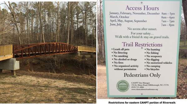
The Occoneechee Speedway Trails are located on Elizabeth Brady Road which is found off US Hwy 70 just east of Hillsborough (not the Bypass 70). There are usually brochures at the trailhead with maps. Use the trailhead to the right - the one on the left is a vehicle access for HOST officials. HOST is Historic Occaneechee Speedway Trail. You start off with a short 0.2 mile walk to access the Spectator Trace Trail...all these other trails other than the main speedway trail are short and uneventful, except for perhaps the Big Bend Trail. The main speedway is just shy of one mile, and still features some of the raised bank turns used during NASCAR days. The old concrete bleachers still exist and the recreated flag stand, announcer's booth, ticket stand and outhouses are on original locations. It is flat and what you would expect for a dirt track except the shoulders are now deep in forest. Between Number 2 and 3 turns, you are along, but not right on the Eno River. It can be quite busy at times. On the other side of the river is Ayr Mount, a renovated historic home. I'm not going to go into the historic value of these properties, except to point out that there are trails on them. Ayr Mount has a one mile Poets Walk Trail, that is free, although to tour the home is a modest fee. Ayr Mount is accessed off St. Mary's Road near Hillsborough. Newly blazed is a portion of the Mountains to Sea Trail, veering off across Cates Creek on a new footbridge, along the southern bank of the Eno on its way to Hwy 70. It is a short round-trip. It is unlikely it will continue beyond Hwy 70 anytime soon, as it runs into some private land beyond 70 near Lawrence Rd. At the far eastern end, the trail crosses a new footbridge connecting it to the Speedway trail system across donated land from the Classic American Homes preservation Trust - owners of Ayr Mount. There are restrictions for this part of the trail as noted below
|
Using this link to the right, you should be able to open an OPENSTREETS Map centered on the area. I strongly suggest changing your base layer to STANDARD to see the latest trails. If your location services are active you can center the map on your current location, and follow the trails on the map. |

|
 BASEMAP COPYRIGHT GOOGLE MAPS; OVERLAY DATA COPYRIGHT EnoTrails.com RIGHT CLICK & "VIEW IMAGE" or "OPEN IN NEW TAB" TO DISPLAY FOR PRINTING JUST THIS MAP. |
|
|
ver. 3.1 ~ © 2011-
|