





 |
 |
 |
 |
 |
 |
|
PUMP STATION AREA |
Trails in the PUMP STATION AREA are accessed from both sides of the Eno River. The Pea Creek Trail is typically accessed from the end of Old Cole Mill Road, found at the Umstead Road/Cole Mill Road stoplight, (See COLE MILL AREA above) and you would hike under the Cole Mill Road bridge. The Dunnagan Trail is accessed most easily from the unmarked (but well-worn) street parking found on Continental Road, off Umstead Drive. Either trail can be combined with the other and accessed from either parking area. The Pump Station Trail is accessed from one of two trailheads on Rivermont Drive, off Cole Mill Road. Either trailhead goes into the trees to do this loop trail in either direction, and there is a connector trail alongside the road between both trailheads. See our separate section on how the Mountains-to-Sea/Laurel Ridge Trail traverses this section. |
| DUNNAGAN TRAIL: | NOTE: All trails marked with an asterisk (*) require access to it from another trail. Consult the maps to determine how best to reach this trail, or read the trail description for options and recommended combined trails. Mileages given here ADD to the distance required to access the trail from another. |
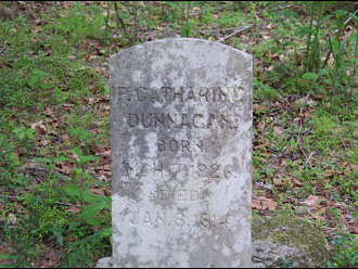
See the great story about Phebe Catherine (Link) Dunnagan on the Eno River Association's Website - CLICK HERE.
|
The Dunnagan Trail is primarily accessed off Continental Road at an unmarked but obvious trailhead with minimal roadside parking. From this trailhead, you go through the woods a short way and are presented with a split in the trail. Describing it clockwise, it will follow alongside a ridgeline on your right, and eventually loop downhill and back on itself to the river. At the point where it hits the river, directly across the Eno River is the old Durham Pumping Station, best accessed on the Pump Station Trail. It is feasible to ford the river at this point, but not easily. I've forded it at low water and it never went beyond my mid-thigh. The trail goes upriver to Pea Creek, where it cuts upcreek slightly and gives you a chance to cross it on a wooden footbridge, tying into the Pea Creek Trail. Continuing uphill on Dunnagan, it loops back to the east again toward the trailhead, but prior to getting there, watch for a lone grave marker for P. Catherine Dunnagan. It sits next to another grave and both appear to be caved in. It is my understanding that they were not dug up, just natural settling. As you stand looking at the readable side of the grave, over your shoulder at about 5 O'Clock and about 100 ft. away are the stone remnants of the family chimney and foundations. Further on the trail, you find the first trail split and back to the north to the trailhead. This trail is most often combined with Pea Creek, and sometimes with the Cole Mill and Bobbitt's Hole trails to extend your hikes. Combining those four trails give you a nearly full loop without doubling back on itself. The Continental Rd. trailhead is preferred over the Old Cole Mill Rd Access point if you plan to hike early or late, as that trailhead is behind locked gates off hours, which change seasonally. Alternatively, you can park on Cole mill right at the ENo River Bridge and access the trail systems on the upriver side at wooden steps. This, too, allows for off-hours hiking.
There is a rumor that the Dunnagan can be followed further downriver and tire into the Sawmill Trail near Guess Road on Social Trails - but unconfirmed at this time.
|
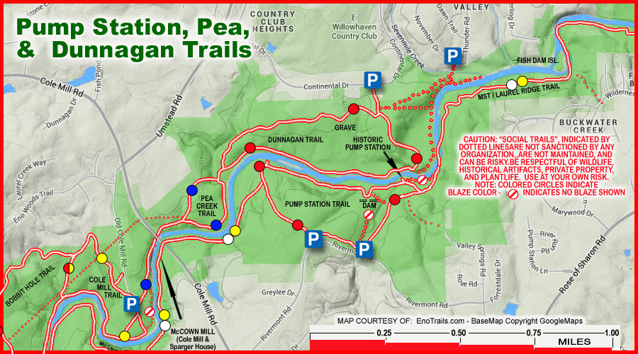 BASEMAP COPYRIGHT GOOGLE MAPS; OVERLAY DATA COPYRIGHT EnoTrails.com RIGHT CLICK & "VIEW IMAGE" or "OPEN IN NEW TAB" TO DISPLAY FOR PRINTING JUST THIS MAP. |
|
|
ver. 3.1 ~ © 2011-
|